User talk:Charles Wood
Upload Text Files?
I want to upload a .kml file containing my best guess for the missile splashes in Zamalka on August 21.
There is no option for either text or kml, Or even kmz.
Can this be changed?
- Hi Charles, no it can't be changed, the file-types are configured on MediaWiki script level where we have no access. You can use the <pre> tag for pre-formatted text on every page, though, which will give you something like the following when you paste your data in. --CE (talk) 11:38, 4 December 2013 (UTC)
<?xml version="1.0" encoding="UTF-8"?>
<kml xmlns="http://www.opengis.net/kml/2.2">
<Document>
<Placemark>
  <name>New York City</name>
  <description>New York City</description>
  <Point>
    <coordinates>-74.006393,40.714172,0</coordinates>
  </Point>
</Placemark>
</Document>
</kml>
I could only have said not me. In fact I can't even get a simple .png or .jpeg to upload lately. This fix seems to work not too bad, just saw it in action. --Caustic Logic (talk) 13:03, 4 December 2013 (UTC)
A quick question: I saw a recent video on LL grenade attack
I seem to recall this was quite old and there is related video from the rooftop and lots of bodies. Is this in your collection? What was the incident? --Charles Wood (talk) 11:45, 27 December 2013 (UTC)
Geolocate ANNA Videos
Jobar Operation August 21 2013
Jobar operation. 1. Beginning
Операция в Джобаре. Часть 1. Начало Jobar operation. 1. Beginning
Video Date: 2013-08-21 (Source lowerlevels on liveleak)
Upload Date: 2013-12-23
Primary camera location Tall tower block
Map View
Operation in Dzhobare. Part 2. Reconnaissance and artillery barrage.
Video Date: 2013-08-21 Plus 0-3 days? (Source lowerlevels on liveleak)
Upload Date: 2013-12-29
Primary camera location Tall tower block
Map View
--Charles Wood (talk) 07:44, 31 December 2013 (UTC)
Operation in Dzhobare. Part 3. Landing troops.
Uploaded yesterday, already subtitled in four languages. --CE (talk) 13:21, 24 January 2014 (UTC)
Operation in Dzhobare. Part 4. IFV Leaves Under Fire.
Uploaded today, subtitled in English, German, Russian --Charles Wood (talk) 23:30, 25 January 2014 (UTC)
- Like Part 3 no need for geolocation. This happens while the alleged Chemical Weapons attack had been going on with first victims reported in Jobar. Just imagine the difference to what's seen if a "proper" CW attack had taken place along this operation. --CE (talk) 00:00, 26 January 2014 (UTC)
- But the wind. Should they have blown up something by accident or else, the model you presented would just carry it in the same east-southeastern direction, leading to the "victims" area. --CE (talk) 00:10, 26 January 2014 (UTC)
Chatter
Looks like the right basic spot, but note sun from the west, I guess, meaning mid-PM. This must be in the cropped off part of the complex just north? With less busses and more buildings inside the fence? And is there a significance to this, or just practicing, or what? Keep at it, either way. :) --Caustic Logic (talk) 04:37, 30 December 2013 (UTC)
I'm using this place as a storage depot for now and also for criticism of my geolocation. No probs about any or all of it being slotted into ACLOS pages if there is a consensus that the descriptions are accurate. Maybe in a bit I'll generate a separate page for it.
I have a longer term plan to geolocate many significant videos - at least from the Damascus area. I've started a private database with a lot of metadata about each video, lats, longs, dates, uploads, notes etc. It has the working title "DatabaseOfDeath". Slightly more problematic is evaporation of videos off YT etc so I have started copying them down. As a secondary project I'm looking at adding metadata internal to the video files c.f. EXIF for jpeg. Webm supports metadata but finding an app to actually add and edit metadata is problematic. I may have to write my own :-(
--Charles Wood (talk) 05:05, 30 December 2013 (UTC)
- Sounds good. I appreciate that it sounds tedious and finally useful. But the methods seem over my head, which I'll take as an excuse to just not gum up your process. I hope you can share the findings here. Any questions, feel free. We're all pretty good at geo-location by now. --Caustic Logic (talk) 06:31, 30 December 2013 (UTC)
- I've been going though this particular video generating metadata. What I have found out is that despite being uploaded on Dec 29 it refers to events some months ago. Quite when I'm not sure but most likely summer 2013
- And yes, it's bloody tedious. I'm guessing one or two videos a day at best. Though at least I'm getting my computer skills back after a bit of a hiatus. Here's a bit of the metadata - still experimental
<?xml version="1.0"?>
<DOD_Version>1.0</DOD_Version>
<Media_File_Name>Syria - SAA in Damascus Al-Qaboun suburb 1806 (Low).webm</Media_File_Name>
<Media_File_DB>RrmAlnZlGyQ.mkv</Media_File_DB>
<Tag>Jobar</Tag>
<Tag>Qaboun</Tag>
<Tag>Damascus</Tag>
<Tag>ANNA</Tag>
<Source>
  <URL>http://www.youtube.com/watch?v=RrmAlnZlGyQ</URL>
  <Upload_Date>2013-12-29</Upload>
  <Date_No_Later>2013-12-29</Date_No_Later>
  <Start_Date></Start_Date>
  <End_Date></End_Date>
  <Uploader>AnnaNews</Uploader>
  <Copyright>AnnaNews</Copyright>
  <Upload_Title>Операция в Джобаре. Часть 2. Рекогносцировка и артподготовка</Upload_Title>
  <Upload_Title_EN>Operation in Dzhobare. Part 2. Reconnaissance and artillery barrage</Upload_Title>
  <Uploader_Comment>Продолжаем цикл фильмов о первых днях операции в Джобаре<Uploader_Comment>
  <Uploader_Comment_EN>Continue a cycle of films about the early days of operation in Dzhobare</Uploader_Comment_EN>
</Source>
<Location>
  <target>
    <Offset_Time>0.0000</Offset_Time>
    <Duration>0</Duration>
    <Lat>33.528045</Lat>
    <Lon>36.328973</Lon>
    <Desc>MultiStory Building</Desc>
    <Map_Symbol>Structure></Map_Symbol>
  </target>
  <Camera>
    <Offset_Time>0.0000</Offset_Time>
    <Duration>0</Duration>
    <Lat>33.529986</Lat>
    <Lon>36.32395</Lon>
    <Azimuth>120</Azimuth>
    <Desc>Overlooking Building</Desc>
    <Map_Symbol>Camera></Map_Symbol>
  </Camera>
</Location>
--Charles Wood (talk) 07:11, 30 December 2013 (UTC)
- I've heard that part of the team is back in Russia on "vacation" and use the time to sort through so-far unpublished material.
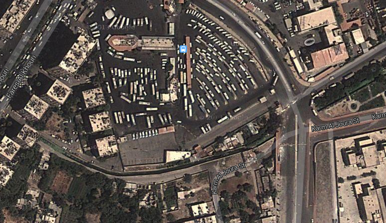
- I'd say you got the general spot but it's not in the "middle tower block" if you mean the three quadratic ones. If you draw a line of sight just at the edge of what is seen from the building, it ends a bit north of the big crossing. On the parking lot that beamer is just touching the pointy little building. Drawing back the line between those two points shows that we are on the higher building north of the three. If we were on the "middle tower block" the pointy building would be out-of-sight to the left. Just a quick impression. --CE (talk) 07:30, 30 December 2013 (UTC)
- I guess you are right. Which means the camera azimuth is closer to 120. The rooftop water-tanks will be on top of the three shorter buildings.
- My good news today is I can now embed metadata into Matroska Container format videos (basically webm). So I have an easy path from a database full of metadata and a YT video to a fully self-documenting video file. Next trick is to see if the metadata survives upload to YT. --Charles Wood (talk) 07:47, 30 December 2013 (UTC)
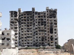
The tower is the Teachers' Tower in Jobar. I think it is still in rebel possession. -- Petri Krohn (talk) 20:41, 30 December 2013 (UTC)
- The video now has German subtitles (thanks to apxwn) and I know why that huge building is called the "Teacher's Tower" - it was the HQ of the Syrian Teacher's Union(!) - that alone must have been reason enough for everybody from Ron Paul to Prince Fatso to fight the "regime"! ;o)
- The flatter association of buildings between the TT and the large crossing viewed from Charles' Tower, with the red-white checkered sides, is the "IT-College". The recordings are from end of August, he says. --CE (talk) 20:52, 30 December 2013 (UTC)
Charles, likely you are aware of it, but one never knows. Saw this analysis of ANNA videos linked over at apxwn again. --CE (talk) 21:17, 30 December 2013 (UTC)
- Yes I'm aware of the analysis. I do have doubts about some of the dates they provide for events. They seem to have mistaken upload dates for event dates in some cases.
- Their chronology is ANNA based and does not necessarily match ground-truth when compared against insurgent videos. For instance there is clear evidence there was an infantry ('Shabiha') assault on the technical school on August 22, while osmint only describes 'Fight for a school in Jobar' on October 16. (Plus their damned map image is rotated 90 degrees!)
- ANNA videos come in at least two categories. The majority are uploaded within a day or so of the event (NEWS). Then a smaller fraction are uploaded some period later (HISTORY)--Charles Wood
- P.S. My video above is not part of the osmint analysis. They seem to have concentrated on the Jobar Qaboun industrial area asides from a sally into Qaboun and some work at the East of Jobar (talk) 00:06, 31 December 2013 (UTC)
- The Zamalka maps are rotated 180 degrees. In fact the conflict area is not in Zamalka at all, but on the Jobar side of the Southern Bypass Road. -- Petri Krohn (talk) 01:09, 31 December 2013 (UTC)
Spam Filters - bypass?
I want to add a link to a superb debunk of the UN report titles "Pigeon Poop on the Pump Handle: A Critique of the Report of the UN Mission to Investigate the Use of Sarin in Damascus"
However the links I use - either to scribd or via a tc abbreviated address get blocked as spam. How do I bypass this? -- Charles Wood (talk) 02:35, 4 January 2014 (UTC)
- http://logophere.com/Syria/Syria%20Docs/Ghouta%20Final%20ver01a.pdf -- Petri Krohn (talk) 03:13, 4 January 2014 (UTC)
- We are also proud to have the author who posted it himself among our membership. Maybe there is some "captcha" thing you have to fill out, Charles? We had that problem at the host we were on before we came here, but frankly, Dennis would have been in the same position. No Idea where the problem lies. (+I signed your post for you) --CE (talk) 03:20, 4 January 2014 (UTC)
Request for Assistance - Gas mapping
I've been using a fairly standard air-dispersion model to map the distribution of Sarin as released by the CW missiles. I use 48kg of Sarin instantaneously evaporated as a starting point (yes I know there is a liquid / vapor fraction but we are looking at cumulative exposure)
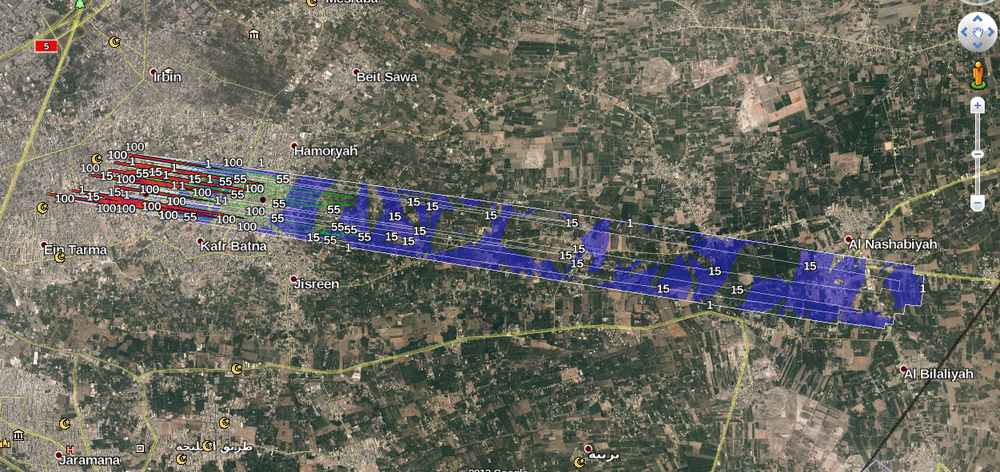
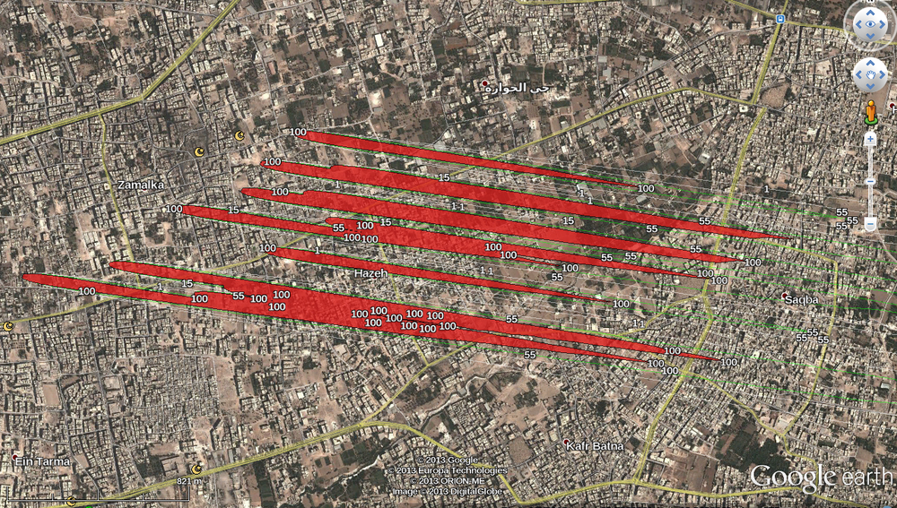
My problem is that my post-processing of the data produces results I don't really expect. For instance eye-effects up to 14 km downwind but lethality only up to 1000-1300m (LCt50) and on a very narrow strip.
I'd like someone numerate and literate and scientific and skilled in spreadsheets to look at my analysis and give informed criticism.
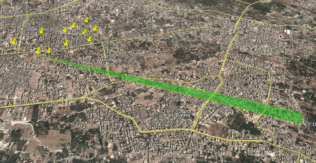
I produced a preliminary image showing the cloud extent based on fairly well defined cloud edges but limited to 3km. Lethal areas are much closer to the centreline and stop at 1000-1300m while eye effects extend far beyond the green area - 14k downwind. The image is a direct output of the computer model using 'instantaneous' values rather than cumulative values. It sets the bounds of interest for individual gas releases.
Contact me at charles.wood2013@yahoo.com.au for data files *if* you are competent and can help.
--Charles Wood (talk) 14:52, 6 January 2014 (UTC)
- A thought: Do we have any idea of how many of the victims (supposedly) died in their homes and how many outside in the open. This should be reflected in the demographics of the victims from each effected area. -- Petri Krohn (talk) 17:46, 6 January 2014 (UTC)
From the two maps I read that practically everyone in Saqba should have been incapacitated. -- Petri Krohn (talk) 01:27, 9 January 2014 (UTC)
- Everyone up to 13 km downwind would be showing miosis - that's 13,000 hectares or 260,000 people at an average 20/hectare (guess)
- At least half the people up to 13km downwind would have noticable breathing and muscle symptoms. (130,000 people - perhaps more because it's more built-up)
- At least half the people up to 5km downwind would be showing severe respiratory and muscle symptoms (min 50,000 people)
--Charles Wood (talk) 02:12, 9 January 2014 (UTC)
- Doing some research on the Ghouta target areas I was surprised to find the urban density of Zamalka was over 230 / hectare in 2004. That's quite high. Quite what the figure in 2013 was is another question. You have 9 years growth but some amount of disturbance from war. My best guess is that the urban density was still quite high and well over the European norm pf 50/hectare and certainly more than the US norm of 20/hectare.
- --Charles Wood (talk) 10:07, 11 January 2014 (UTC)
- Some help in estimating population density. I believe most of Zamalka was abandoned by August 21. Life in Saqba seems like normal. -- Petri Krohn (talk) 13:16, 11 January 2014 (UTC)
- Zamalka and Saqba are contiguous. Zamalka is also contiguous with Irbin. Irbin was closer to the fighting in the Jobar / Qaboun industrial area than Zamalka. It seems there was still significant populaton in Irbin, just not in the immediate vicinity of the Southern bypass. I'm surprised that Zamalka, which wasn't the scene of any heavy engagements, was also deserted. Perhaps in the immediate vicinity of the Southern Bypass? But the rest? I doubt the Zamalka parts near Saqba were empty and this is where the gas attacks are alleged. --Charles Wood (talk) 22:32, 11 January 2014 (UTC)
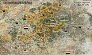
- I do not think anyone has done a proper study of Ghouta population and depopulation before August 21 based on solid video evidence. What we do have is this map by Syrian Perspective. He claims all the main roads in Ghouta are "contested". I have no idea what this really means, if anything. Maybe the SAA sen three T72s down the road and one of them got through. Maybe the roads had been targeted by thermobaric UMLACAs to cave in the tunnels underneath. What is interesting is the green spots. Any civilian population living under rebel control would most likely be concentrated in these areas. -- Petri Krohn (talk) 02:52, 12 January 2014 (UTC)
- Zamalka and Saqba are contiguous. Zamalka is also contiguous with Irbin. Irbin was closer to the fighting in the Jobar / Qaboun industrial area than Zamalka. It seems there was still significant populaton in Irbin, just not in the immediate vicinity of the Southern bypass. I'm surprised that Zamalka, which wasn't the scene of any heavy engagements, was also deserted. Perhaps in the immediate vicinity of the Southern Bypass? But the rest? I doubt the Zamalka parts near Saqba were empty and this is where the gas attacks are alleged. --Charles Wood (talk) 22:32, 11 January 2014 (UTC)
From the BBC:
- Growing suffering of Syria's besieged civilians – Leana Hosea, 5 December 2013
- This means the electricity has been cut and no food, medicine or gas can enter the town, only bombs rain down. The UN (office for the coordination of Humanitarian Affairs) have expressed grave concern about reports that over half a million people remain trapped in rural Damascus and there are cases of severe malnutrition amongst children.
From Wikipedia:
- Greater Damascus, a metropolitan area with more than 4 million inhabitants...
-- Petri Krohn (talk) 10:34, 14 January 2014 (UTC)
Haber's law
I have been wondering how to model the effects of CW inside houses. How much of the outside concentration would seep in? Now I see that this is unnecessary; the Ct values (concentration * time) inside would be exactly the same as outside! If sarin follows Haber's law, then the lethality inside would the same as outside. It would just take longer for victims to receive the lethal dose. If the victims were sleeping inside, as claimed, they might die without ever waking up. -- Petri Krohn (talk) 09:39, 11 January 2014 (UTC)
- There is a fixed duration of the cloud. If there is limited gas transport between inside and out then inside will be safer. You saw this in Israel during the Gulf wars where people were told to seal up a room with masking tape in anticipation of a CW attack. This works for Sarin but not for longer persistence agents like VX.
- No, you are wrong. Krohn's corollary to Haber's law says, that in a gas attack you are as dead inside as you are outside.
- The only way to save oneself in the lethal zone would be to go outside as soon as the concentration outside falls below the level inside. Would people be clever enough to do so? How would they know it is safe outside? "Evil Assad" might have another barrage coming. Maybe the first attack was just an "unmasking" operation to get the people out into the open.
- In the non-lethal zones people would be killing themselves by taking the wrong steps and sealing themselves and a lethal dose of gas inside. It was very hot in Damascus on August 21, 2013; above average with a daytime maximumf of 37C and 23C at 2 am. People would be sleeping with their windows wide open. As soon as they knew of the gas attack they would close the windows. They might notice the panic on the street. They might already have symptoms, or the "sarin" might be accompanied with a smell. There were reports that megaphones on mosques were broadcasting instructions for people to seal themselves inside. By the time people reacted it may have been too late, there was already a lethal dose inside. -- Petri Krohn (talk) 02:26, 12 January 2014 (UTC)
- Of course it would be too late once the mosques broadcast the alarm. The gas cloud - just a big puff - passed each location at between 10 and 18 km/h and the duration of the cloud was tens to hundreds of seconds.
- As a person who lives in a hot climate (yesterday was 44C and overnight 30C, and I spent much of the day ducking from hundreds of roof-top helicopter bombing raids trying to stop my suburb burning down) I think your estimate of all open windows isn't really realistic. Personally I have no air-con and I tend to keep the windows shut whenever outside is hotter than in. Most of my neighbours however have split cycle air-con where there is no air exchange at all. The aircon keeps the inside cool by cooling inside air. Evaporative air-con doesn't really work in multi-story apartments so you see an awful lot of individual dwellings with split cycle with the external heat exchanger on the outside wall or balcony (and this is in most countries I travel to) --Charles Wood (talk) 04:02, 12 January 2014 (UTC)
ISW Report 26 January 2014
I've read this new report which will likely become a poster-child of the Syria Wets.
Emulating Dorothy Parker, I report Tonstant Weader fwowed up!
Jeez what an emporium of bile wrapped up in a cloak of mil-speak!
Wrong on so many details. Reliant on known flawed US intelligence and 'prominent bloggers'. Focused on Bashar guilt and hatred of Hezbollah and Iran, and a narrative purely designed to support that at the expense of any vestige of truth.
Who funds the ISW? John McCain? --Charles Wood (talk) 12:22, 28 January 2014 (UTC)
- (ISW=Institute for the Study of War) On the last question, I don't know. The same people who fund McCain, quite likely. This is just silly:
- On August 20th the Syrian military began Operation Capital Shield, their largest-ever Damascus offensive, aimed at decisively ending the deadlock in key contested terrain around the city. ... The plan was to launch a spectacular chemical attack on contested rebel support zones ... While the exact timing of the chemical attacks may or may not have been a snap decision, it is clear that the chemical weapons launched at numerous neighborhoods in the Damascus suburbs in the early morning of August 21st served as the opening volley of a well-planned and well-executed regime counter-offensive in Damascus."
- They say the operation was planned to begin then, roughly, so they yes, "the regime" decided to use this type opening shot on that day in their story. Why it might even be a snap decision, may be a nod to what a stupid day it would be to decide on - exactly a year after Obama first iterated his "red line," and a couple days after UN CW inspectors arrived. Turned one way, all that could be said then was the regime authors were "pretty f@@@@@g stupid." But when one is studying war and strategy and excellence, with fancy typefaces, months later and without at the moment considering those side-issues, suddenly it was "a well-planned and well-executed regime counter-offensive." Laughing sounds! Study away institute! --Caustic Logic (talk) 13:58, 28 January 2014 (UTC)
- One presumes they have "studied" the rocket trajectories in this attack? No, they're just a bullshit front group providing safely filtered smart-sounding stuff for McCain-types to point to, so their easily-scripted foreign policy points sound all "studied." --Caustic Logic (talk) 14:24, 28 January 2014 (UTC)
- Just to reiterate the stupidity or malice in this piece. Unless I'm seriously mistaken the only attacks on and after August 21 for a couple of weeks were the Teacher's tower attack - uploaded by me above - and some sallies on the Technical school and the power sub-station area close to Teacher's Tower.
- The actual gas attacks were not on several neighbourhoods as stated (fake US intelligence in August September) but on Zamalka - far away from any of the fighting.
- BTW I'm doing a report on Moadimiyah that shows that the alleged gas attack there would have gassed Mezzeh airbase, the Mezzeh suburb full of foreign diplomats, and even the Presidential Palace. --Charles Wood (talk) 14:32, 28 January 2014 (UTC)
- Side note on McCain: He hangs around with Ukrainian Neo-Nazis these days... --CE (talk) 14:44, 28 January 2014 (UTC)
- Yikes. Thanks for a visual glimpse into something I haven't followed. --Caustic Logic (talk) 00:40, 29 January 2014 (UTC)
- Side note on McCain: He hangs around with Ukrainian Neo-Nazis these days... --CE (talk) 14:44, 28 January 2014 (UTC)
TRPINTEL1
Interesting analytic resource for a number of recent battlefields, especially today for Aleppo Prison attack.
--Charles Wood (talk) 11:15, 11 February 2014 (UTC)
Jobar Qaboun Industrial Area August 21
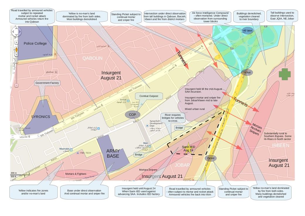
I've prepared a map of the Jobar Qaboun Industrial Area for August 21 with notes on events within a few days.
I'd like robust criticism. I can also provide justification for much of what is shown. In particular the no-man's land areas are drawn based on satellite photos of demolished buildings. The assumption is they have been leveled to deny insurgents cover and allow for free-fire especially from the major arterial roads.
- I have nothing to add or subtract at the moment. From the bit I've seen of Jobar imagery, your notes seem fair. This is where the Volcano/Burkan (new monicker at WhoGhouta) rockets were probably fired from, correct? Such details will help. You mentioned colors - they're fine but too bright. I found a simple desturation to grayer tones is easier on the eyes and still color-coded enough. Could post that, or let you try it yourself. ... And I Just wanted to say hi, and so glad to see the site back up, and you at work, and Denis' mammoth new report - I'm down with getting back on subject with a Ghoua revival. --Caustic Logic (talk) 11:41, 18 April 2014 (UTC)
I've updated the map with more detail - hit refresh to see.
And no. This is very unlikely to be the launching point for the missiles. The tactical situation was very front-line and the areas under SAA control were subject to sniper fire, mortar fire, and direction observation from tall buildings in Irbeen.
There is also the logistic problem of getting the launchers in. The only access is along Kenzi St and it runs along a row of buildings occipied by insurgents. Travel on that bit of Kenzi needed armoured vehicles. Soft skinned launchers would be screwed. --Charles Wood (talk) 01:10, 21 April 2014 (UTC)
Jabiya Battalion 74 gas attack?
Some decomposition but not nearly enough bullet holes.
- A sad day for Syria, some day or two before this. Says al-Nusra killed more than 70 here. Not sure where this battalion 74 hillside Jabiya ( الجابية ) is. Latakia? It seems there's a lack of shooting, but that could largely be the absorbency of dirt. If this was one of those threatened CW attacks ... you called it first here. Could be. I'll be the first to declare that if so, Assad gassed his own soldiers, just to let the rebels take over but look bad :) --Caustic Logic (talk) 12:38, 27 April 2014 (UTC)
- No one could accuse you of being cynical!
- Pedantic mode on. Using my new-found skills on pronouncing basic Arabic, الجابية shoud be promounced (Al) Jaabyah not Jabiya - notwithstanding Google. The vertical stroke mid-word (ا) is a long vowel to the left of the ج (j) so Jaa not Ja. Plus the end character with the umlaut is a ta marbuta so an 'h' sound in this context
--Charles Wood (talk) 13:06, 27 April 2014 (UTC)
Nawa missile barrage
Really cool view of the receiving end of a Grad 122mm barrage (or maybe 107mm). Or is it?
at Nawa
My problem is the explosions look just like CGI and the smoke is the wrong colour. It's white/grey/light brown which is very characteristic of Calcium Ammonium Nitrate explosions. Standard military explosives are almost always black smoke.
I'ts most likely real but it does look dodgy. Any comments?
- Really black smoke in Deir ez-Zor and an actual missile - missing on the Dawa videos
- and Grad missile strike - note darker smoke.
- Or this one in Darayya
- I'm starting to strongly suspect the Dawa video is fake --Charles Wood (talk) 00:06, 18 May 2014 (UTC)
- Rewatching it I think it's just a bunch of small CAN IEDs being set off to simulate 'indiscrimiate missile barrage on peaceful town' along with dramatic commentary. There are no incoming missiles and the smoke is not military grade explosive --Charles Wood (talk) 01:03, 18 May 2014 (UTC)
Brown Noses fucks up yet again
Eliot Higgins has posted yet another dramatic video link to Syria claiming it's evidence of a chlorine gas attack by the Assad regime baby-eaters.
Compare and contrast a real chlorine leak!
Just for the uninitiated here's the breakdown
- Chlorine concentrations dense enough to appear even slightly green must be approaching 100%! And just after a bomb explosion!
- To get the amount of gas seen would require a truckload or three of chlorine. Not a blown-up mini-cyclinder as previously alleged. And by truckload I means truckload!
- And there is no mist! The real chlorine video shows exactly what happens - lots and lots of mist due to water vapour in the air.
Now let's look at a simpler explanation. It's FAKE! It's a green smoke grenade fired off a few minutes earlier in still-air conditions. From my personal military experience that tint in the air is exactly what a smoke grenade looks like after a few minutes.
You can just start to see the effect in the left of this image Greek smoke. Groovy!! --Charles Wood (talk) 07:11, 24 May 2014 (UTC)
Dutch Intellectuals Apologize to Putin for Lies on MH17, Syria, Ukraine...
Letter here in my discussion till somone else figures out where to put it.
A letter sent by a prominent Dutch Professor to Russian president Vladimir Putin has attracted much media attention in Europe. The letter was written by Professor Cees Hamelink and signed by dozens of Dutch intellectuals and professors. Below is the letter in its entirety.
Dear Mr. President Putin,
Please accept our apologies on behalf of a great many people here in the Netherlands for our Government and our Media. The facts concerning MH17 are twisted to defame you and your country.
We are powerless onlookers, as we witness how the Western Nations, led by the United States, accuse Russia of crimes they commit themselves more than anybody else. We reject the double standards that are used for Russia and the West. In our societies, sufficient evidence is required for a conviction. The way you and your Nation are convicted for 'crimes' without evidence, is ruthless and despicable.
You have saved us from a conflict in Syria that could have escalated into a World War. The mass killing of innocent Syrian civilians through gassing by ‘Al-‐Qaeda’ terrorists, trained and armed by the US and paid for by Saudi Arabia, was blamed on Assad. In doing so, the West hoped public opinion would turn against Assad, paving the way for an attack on Syria.
Not long after this, Western forces have built up, trained and armed an ‘opposition’ in the Ukraine, to prepare a coup against the legitimate Government in Kiev. The putschists taking over were quickly recognized by Western Governments. They were provided with loans from our tax money to prop their new Government up.
The people of the Crimea did not agree with this and showed this with peaceful demonstrations. Anonymous snipers and violence by Ukrainian troops turned these demonstrations into demands for independence from Kiev. Whether you support these separatist movements is immaterial, considering the blatant Imperialism of the West.
Russia is wrongly accused, without evidence or investigation, of delivering the weapons systems that allegedly brought down MH17. For this reason Western Governments claim they have a right to economically pressure Russia.
We, awake citizens of the West, who see the lies and machinations of our Governments, wish to offer you our apologies for what is done in our name. It’s unfortunately true, that our media have lost all independence and are just mouthpieces for the Powers that Be. Because of this, Western people tend to have a warped view of reality and are unable to hold their politicians to account.
Our hopes are focused on your wisdom. We want Peace. We see that Western Governments do not serve the people but are working towards a New World Order. The destruction of sovereign nations and the killing of millions of innocent people is, seemingly, a price worth paying for them, to achieve this goal.
We, the people of the Netherlands, want Peace and Justice, also for and with Russia. We hope to make clear that the Dutch Government speaks for itself only. We pray our efforts will help to diffuse the rising tensions between our Nations.
Sincerely,
Professor Cees Hamelink
--Charles Wood (talk) 00:42, 8 September 2014 (UTC)
